
Thank you for supporting this site ❤️
Make a donation
Make a donation
Blue Ridge Summit topographic map
Click on the map to display elevation.
Thank you for supporting this site ❤️
Make a donation
Make a donation
Blue Ridge Summit
Pennsylvania Route 16 passes through Blue Ridge Summit, leading east down the mountain to Emmitsburg, Maryland, and west downhill to Waynesboro. The highway elevation at Blue Ridge Summit is 1,330 feet (410 m), compared to elevations of 500 and 700 feet (150 and 210 m) east and west of the mountain, respectively. Mount Dunlop, overlooking Blue Ridge Summit to the west, rises to a summit of 1,700 feet (520 m). Monterey Pass is northwest and slightly downhill from the community along PA 16.
Thank you for supporting this site ❤️
Make a donation
Make a donation
About this map
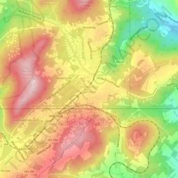
Name: Blue Ridge Summit topographic map, elevation, terrain.
Average elevation: 400 m
Minimum elevation: 244 m
Maximum elevation: 516 m
Thank you for supporting this site ❤️
Make a donation
Make a donation