
Thank you for supporting this site ❤️
Make a donation
Make a donation
Rothaus topographic map
Click on the map to display elevation.
Thank you for supporting this site ❤️
Make a donation
Make a donation
About this map
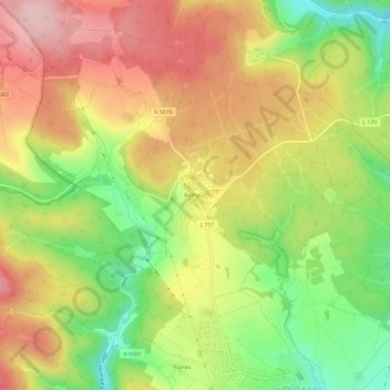
Name: Rothaus topographic map, elevation, terrain.
Average elevation: 962 m
Minimum elevation: 835 m
Maximum elevation: 1,081 m
Thank you for supporting this site ❤️
Make a donation
Make a donation
Other topographic maps
Click on a map to view its topography, its elevation and its terrain.
Schlüchtsee
Deutschland > Baden-Württemberg > Landkreis Waldshut > Grafenhausen
Average elevation: 938 m