
Pipa topographic map
Click on the map to display elevation.
About this map
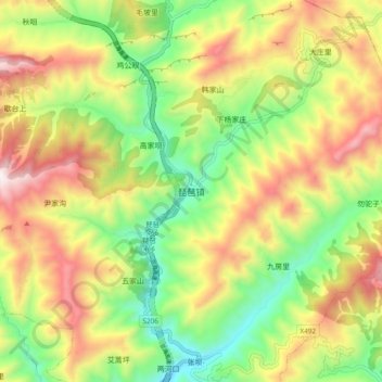
Name: Pipa topographic map, elevation, terrain.
Location: Pipa, Wudu District, Longnan, Gansu, China (33.12649 105.27457 33.20649 105.35457)
Average elevation: 1,738 m
Minimum elevation: 1,296 m
Maximum elevation: 2,287 m
Other topographic maps
Click on a map to view its topography, its elevation and its terrain.
Hezuo City
With an elevation of nearly 3,000 metres (9,800 ft), Hezuo has an alpine subarctic climate (Köppen Dwc), with long, very cold, dry winters, and short, mild summers. The monthly daily mean temperature in January, the coldest month, is −9.3 °C (15.3 °F), while the same figure for July, the warmest month, is…
Average elevation: 3,249 m
Jingtai County
The county is largely hilly and mountainous, with an elevation ranging from 1,276 metres (4,186 ft) to 3,321 metres (10,896 ft) above sea level. The county is home to a number of prominent tourist sites, such as the Yellow River Stone Forest, Yongtai Fortress, and other locations.
Average elevation: 1,918 m
Zhangye Danxia National Geological Park
China > Gansu > Linze County > Nantai
Average elevation: 1,759 m
Qingyang
Qingyang is the easternmost prefecture-level division of Gansu and is thus sometimes referred to as "Longdong" (Chinese: 陇东; pinyin: Lǒng dōng). It forms an administrative peninsula, as it is surrounded, on all sides but the south, by Shaanxi and Ningxia. It is in the lower middle part of the Yellow…
Average elevation: 1,454 m
Maqu County
Maqu County (simplified Chinese: 玛曲县; traditional Chinese: 瑪曲縣; pinyin: Mǎqū Xiàn; Tibetan: རྨ་ཆུ་རྫོང་།, Wylie: Rma chu rdzong, ZYPY: Maqu Zong) is a county of the Gannan Tibetan Autonomous Prefecture in the south of Gansu province of the People's Republic of China,…
Average elevation: 3,812 m
Lanzhou New Area
China > Gansu > Gaolan County
Lanzhou's main urban area is constrained in size by its geographical topography, since it is a typical valley sandwiched by mountains, with the Yellow River crossing by. The topography of Lanzhou hampers this city to become a continuous megacity like Beijing or Xi’an. The General Office of the State Council…
Average elevation: 2,061 m