
Thank you for supporting this site ❤️
Make a donation
Make a donation
Gadernheim topographic map
Click on the map to display elevation.
Thank you for supporting this site ❤️
Make a donation
Make a donation
Gadernheim
Gadernheim liegt im Vorderen Odenwald an der oberen Lauter und östlich der Kerngemeinde Reichenbach. Zur Gemarkung gehört im Nordosten das Quelltal der Lauter und die höchste Erhebung im hessischen Odenwald, die 605 Meter hohe bewaldete Neunkircher Höhe mit dem Kaiserturm.
Thank you for supporting this site ❤️
Make a donation
Make a donation
About this map
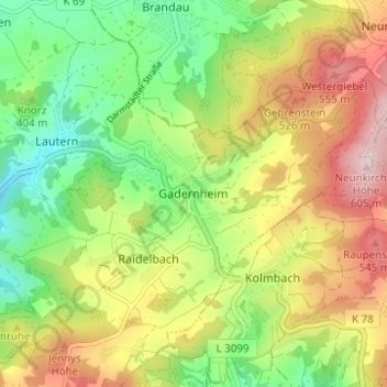
Name: Gadernheim topographic map, elevation, terrain.
Average elevation: 412 m
Minimum elevation: 260 m
Maximum elevation: 607 m
Thank you for supporting this site ❤️
Make a donation
Make a donation
Other topographic maps
Click on a map to view its topography, its elevation and its terrain.
Schannenbach
Deutschland > Hessen > Kreis Bergstraße > Lautertal > Schannenbach
Die Statistisch-topographisch-historische Beschreibung des Großherzogthums Hessen berichtet 1829 über Schannenbach.
Average elevation: 464 m