
Thank you for supporting this site ❤️
Make a donation
Make a donation
Brainerd topographic map
Click on the map to display elevation.
Thank you for supporting this site ❤️
Make a donation
Make a donation
About this map
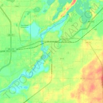
Name: Brainerd topographic map, elevation, terrain.
Location: Brainerd, Crow Wing County, Minnesota, 56401, United States (46.31263 -94.24592 46.38862 -94.14238)
Average elevation: 370 m
Minimum elevation: 348 m
Maximum elevation: 395 m
Thank you for supporting this site ❤️
Make a donation
Make a donation
Other topographic maps
Click on a map to view its topography, its elevation and its terrain.
Middle Cullen Lake
United States > Minnesota > Crow Wing County > Pequot Lakes
Average elevation: 372 m
Thank you for supporting this site ❤️
Make a donation
Make a donation