
Thank you for supporting this site ❤️
Make a donation
Make a donation
Indian Town Hammock topographic map
Click on the map to display elevation.
Thank you for supporting this site ❤️
Make a donation
Make a donation
About this map
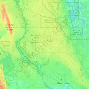
Name: Indian Town Hammock topographic map, elevation, terrain.
Average elevation: 16 m
Minimum elevation: 2 m
Maximum elevation: 57 m
Thank you for supporting this site ❤️
Make a donation
Make a donation
Other topographic maps
Click on a map to view its topography, its elevation and its terrain.
Kissimmee Prairie Preserve State Park
United States > Florida > Okeechobee County
Average elevation: 20 m