
Thank you for supporting this site ❤️
Make a donation
Make a donation
Ixworth topographic map
Click on the map to display elevation.
Thank you for supporting this site ❤️
Make a donation
Make a donation
About this map
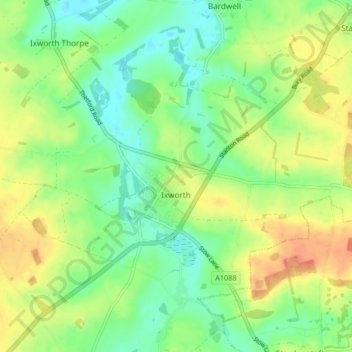
Name: Ixworth topographic map, elevation, terrain.
Location: Ixworth, West Suffolk, Suffolk, England, United Kingdom (52.28476 0.78691 52.31997 0.86898)
Average elevation: 42 m
Minimum elevation: 22 m
Maximum elevation: 67 m
Thank you for supporting this site ❤️
Make a donation
Make a donation
Other topographic maps
Click on a map to view its topography, its elevation and its terrain.
Thank you for supporting this site ❤️
Make a donation
Make a donation
Thank you for supporting this site ❤️
Make a donation
Make a donation
Thank you for supporting this site ❤️
Make a donation
Make a donation
Thank you for supporting this site ❤️
Make a donation
Make a donation
Lower Green
United Kingdom > England > Suffolk > West Suffolk > Higham > Lower Green
Average elevation: 67 m
Blackthorpe
United Kingdom > England > Suffolk > West Suffolk > Rougham > Blackthorpe
Average elevation: 63 m
Thank you for supporting this site ❤️
Make a donation
Make a donation