
Thank you for supporting this site ❤️
Make a donation
Make a donation
Sula topographic map
Click on the map to display elevation.
Thank you for supporting this site ❤️
Make a donation
Make a donation
About this map
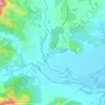
Name: Sula topographic map, elevation, terrain.
Location: Sula, San Jose, Tarlac, Central Luzon, Philippines (15.44257 120.37270 15.48257 120.41270)
Average elevation: 146 m
Minimum elevation: 99 m
Maximum elevation: 395 m
Thank you for supporting this site ❤️
Make a donation
Make a donation
Other topographic maps
Click on a map to view its topography, its elevation and its terrain.