
Thank you for supporting this site ❤️
Make a donation
Make a donation
Holmestrand topographic map
Click on the map to display elevation.
Thank you for supporting this site ❤️
Make a donation
Make a donation
About this map
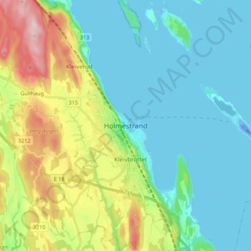
Name: Holmestrand topographic map, elevation, terrain.
Location: Holmestrand, Vestfold, 3080, Norge (59.44996 10.27504 59.52996 10.35504)
Average elevation: 68 m
Minimum elevation: -30 m
Maximum elevation: 262 m
Thank you for supporting this site ❤️
Make a donation
Make a donation
Other topographic maps
Click on a map to view its topography, its elevation and its terrain.
Thank you for supporting this site ❤️
Make a donation
Make a donation