
Make a donation
Chudleigh Knighton topographic map
Click on the map to display elevation.
Make a donation
About this map
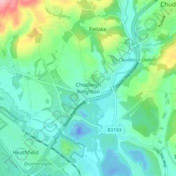
Name: Chudleigh Knighton topographic map, elevation, terrain.
Average elevation: 45 m
Minimum elevation: -39 m
Maximum elevation: 197 m
Make a donation
Other topographic maps
Click on a map to view its topography, its elevation and its terrain.
Teignmouth Beach
United Kingdom > England > Devon > Teignbridge > Teignmouth > Shaldon
Average elevation: 24 m
Make a donation
Make a donation
Make a donation
Tedburn St. Mary
United Kingdom > England > Devon > Teignbridge > Tedburn St Mary
Average elevation: 137 m
Shillingford St. George
United Kingdom > England > Devon > Teignbridge > Shillingford St George
Average elevation: 66 m
Make a donation
Abbotskerswell
United Kingdom > England > Devon > Teignbridge > Abbotskerswell
Average elevation: 66 m
Make a donation
Make a donation
Stokeinteignhead
United Kingdom > England > Devon > Teignbridge > Stokeinteignhead
Average elevation: 63 m
Make a donation
Dawlish
United Kingdom > England > Devon > Teignbridge
Little of note happened at Dawlish until the end of the 18th century, when seaside locations on the south coast started to become popular with the wealthy, mainly caused by George III making Weymouth in Dorset his summer holiday residence from 1789. In May 1795, the antiquarian and topographer John Swete spent…
Average elevation: 44 m
Make a donation
Make a donation
Make a donation
Moretonhampstead
United Kingdom > England > Devon > Teignbridge > Moretonhampstead
Average elevation: 237 m
Make a donation
Make a donation
Make a donation
Dawlish
United Kingdom > England > Devon > Teignbridge
Little of note happened at Dawlish until the end of the 18th century, when seaside locations on the south coast started to become popular with the wealthy, mainly caused by George III making Weymouth in Dorset his summer holiday residence from 1789. In May 1795, the antiquarian and topographer John Swete spent…
Average elevation: 44 m
Make a donation