
Rennes-les-Bains topographic map
Interactive map
Click on the map to display elevation.
About this map
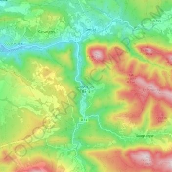
Name: Rennes-les-Bains topographic map, elevation, terrain.
Average elevation: 463 m
Minimum elevation: 234 m
Maximum elevation: 794 m
Other topographic maps
Click on a map to view its topography, its elevation and its terrain.
Ruisseau de la Forêt
France > Occitanie > Aude > Rennes-les-Bains
Ruisseau de la Forêt, Rennes-les-Bains, Limoux, Aude, Occitanie, France métropolitaine, 11190, France
Average elevation: 496 m