
Thank you for supporting this site ❤️
Make a donation
Make a donation
Taranes topographic map
Click on the map to display elevation.
Thank you for supporting this site ❤️
Make a donation
Make a donation
About this map
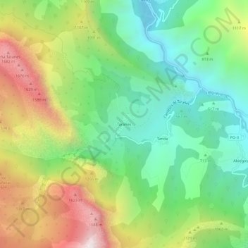
Name: Taranes topographic map, elevation, terrain.
Location: Taranes, Ponga, Asturias, 33557, España (43.18032 -5.23190 43.22032 -5.19190)
Average elevation: 912 m
Minimum elevation: 327 m
Maximum elevation: 1,864 m
Thank you for supporting this site ❤️
Make a donation
Make a donation
Other topographic maps
Click on a map to view its topography, its elevation and its terrain.