Geolocate

黄盖湖镇 topographic map

Interactive map

Click on the map to display elevation.

About this map

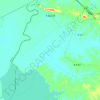
Name: 黄盖湖镇 topographic map, elevation, terrain.

Location: 黄盖湖镇, 赤壁市, 咸宁市, 湖北省, 中国 (29.73989 113.54318 29.82086 113.60668)

Average elevation: 26 m

Minimum elevation: 14 m

Maximum elevation: 78 m

Other topographic maps

Click on a map to view its topography, its elevation and its terrain.

赵李桥镇

中国 > 湖北省 > 赤壁市

赵李桥镇, 赤壁市, 咸宁市, 湖北省, 中国

Average elevation: 213 m

蒲圻街道

中国 > 湖北省 > 赤壁市

蒲圻街道, 赤壁市, 咸宁市, 湖北省, 中国

Average elevation: 67 m

车埠镇

中国 > 湖北省 > 赤壁市

车埠镇, 赤壁市, 咸宁市, 湖北省, 中国

Average elevation: 44 m