
Thank you for supporting this site ❤️
Make a donation
Make a donation
Margajaya topographic map
Click on the map to display elevation.
Thank you for supporting this site ❤️
Make a donation
Make a donation
About this map
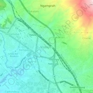
Name: Margajaya topographic map, elevation, terrain.
Location: Margajaya, West Bandung, West Java, Java, 40552, Indonesia (-6.86839 107.48193 -6.82839 107.52193)
Average elevation: 725 m
Minimum elevation: 640 m
Maximum elevation: 959 m
Thank you for supporting this site ❤️
Make a donation
Make a donation
Other topographic maps
Click on a map to view its topography, its elevation and its terrain.
Ir. H. Juanda Grand Forest Park
Indonesia > West Java > West Bandung > Langensari
Average elevation: 1,101 m
Thank you for supporting this site ❤️
Make a donation
Make a donation
DUSUN PALASARI DESA CINTA ASIH KC. CIPONGKOR KAB. BANDUNG BARAT
Indonesia > West Java > West Bandung
Average elevation: 1,013 m
Outbond Ciwangun Indah Camp
Indonesia > West Java > West Bandung > Kertawangi
Average elevation: 1,447 m