
Thank you for supporting this site ❤️
Make a donation
Make a donation
Mt Harrison topographic map
Click on the map to display elevation.
Thank you for supporting this site ❤️
Make a donation
Make a donation
About this map
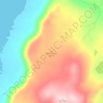
Name: Mt Harrison topographic map, elevation, terrain.
Location: Mt Harrison, Huon Valley, Tasmania, Australia (-54.59164 158.86301 -54.59154 158.86311)
Average elevation: 167 m
Minimum elevation: -1 m
Maximum elevation: 347 m
Thank you for supporting this site ❤️
Make a donation
Make a donation
Other topographic maps
Click on a map to view its topography, its elevation and its terrain.
Thank you for supporting this site ❤️
Make a donation
Make a donation
Thank you for supporting this site ❤️
Make a donation
Make a donation
Macquarie Island
Australia > Tasmania > Macquarie Island Station
Macquarie Island is about 34 km (21 mi) long and 5 km (3 mi) wide, with an area of 128 km2 (49 sq mi). The island consists of plateaus at north and south ends, each of 150–200 m (490–660 ft) elevation, joined by a low, narrow isthmus. The high points include Mount Elder on the north-east coastal ridge at…
Average elevation: 20 m
Thank you for supporting this site ❤️
Make a donation
Make a donation