
Thank you for supporting this site ❤️
Make a donation
Make a donation
Picacho Peak topographic map
Click on the map to display elevation.
Thank you for supporting this site ❤️
Make a donation
Make a donation
About this map
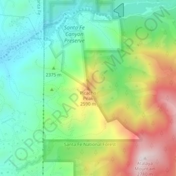
Name: Picacho Peak topographic map, elevation, terrain.
Location: Picacho Peak, Santa Fe County, New Mexico, United States (35.67851 -105.88674 35.67861 -105.88664)
Average elevation: 2,409 m
Minimum elevation: 2,204 m
Maximum elevation: 2,769 m
Thank you for supporting this site ❤️
Make a donation
Make a donation
Other topographic maps
Click on a map to view its topography, its elevation and its terrain.