
Thank you for supporting this site ❤️
Make a donation
Make a donation
Cantone topographic map
Click on the map to display elevation.
Thank you for supporting this site ❤️
Make a donation
Make a donation
About this map
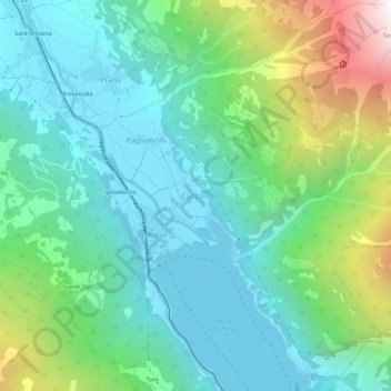
Name: Cantone topographic map, elevation, terrain.
Location: Cantone, Poschiavo, Bernina, Grisons, 7746, Switzerland (46.27697 10.06538 46.31697 10.10538)
Average elevation: 1,401 m
Minimum elevation: 949 m
Maximum elevation: 2,710 m
Thank you for supporting this site ❤️
Make a donation
Make a donation
Other topographic maps
Click on a map to view its topography, its elevation and its terrain.