
Thank you for supporting this site ❤️
Make a donation
Make a donation
Carinthia topographic map
Click on the map to display elevation.
Thank you for supporting this site ❤️
Make a donation
Make a donation
About this map
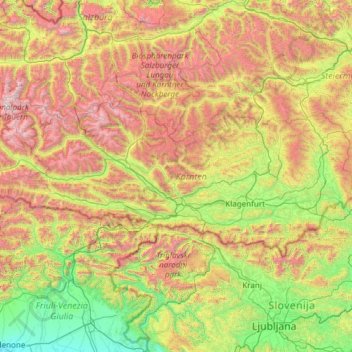
Name: Carinthia topographic map, elevation, terrain.
Location: Carinthia, Austria (46.37230 12.65683 47.13130 15.06515)
Average elevation: 1,095 m
Minimum elevation: 16 m
Maximum elevation: 3,652 m
Thank you for supporting this site ❤️
Make a donation
Make a donation
Other topographic maps
Click on a map to view its topography, its elevation and its terrain.
Thank you for supporting this site ❤️
Make a donation
Make a donation
Sportgastein
Austria > Salzburg > Bezirk St. Johann im Pongau > Bad Gastein > Naßfeld
Average elevation: 1,856 m