
Thank you for supporting this site ❤️
Make a donation
Make a donation
Bandraboua topographic map
Click on the map to display elevation.
Thank you for supporting this site ❤️
Make a donation
Make a donation
About this map
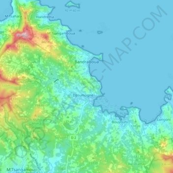
Name: Bandraboua topographic map, elevation, terrain.
Location: Bandraboua, Mayotte, 97650, France (-12.76235 45.08867 -12.67279 45.15887)
Average elevation: 78 m
Minimum elevation: -4 m
Maximum elevation: 443 m
Thank you for supporting this site ❤️
Make a donation
Make a donation
Other topographic maps
Click on a map to view its topography, its elevation and its terrain.