
Thank you for supporting this site ❤️
Make a donation
Make a donation
Werningerode topographic map
Click on the map to display elevation.
Thank you for supporting this site ❤️
Make a donation
Make a donation
About this map
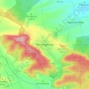
Name: Werningerode topographic map, elevation, terrain.
Average elevation: 295 m
Minimum elevation: 224 m
Maximum elevation: 397 m
Thank you for supporting this site ❤️
Make a donation
Make a donation
Other topographic maps
Click on a map to view its topography, its elevation and its terrain.
Weißenborn-Lüderode
Deutschland > Thüringen > Landkreis Eichsfeld > Sonnenstein
Average elevation: 271 m
Thank you for supporting this site ❤️
Make a donation
Make a donation