
Villa Martín topographic map
Interactive map
Click on the map to display elevation.
About this map
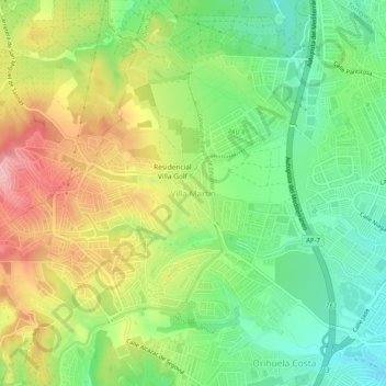
Name: Villa Martín topographic map, elevation, terrain.
Average elevation: 74 m
Minimum elevation: 10 m
Maximum elevation: 161 m
Other topographic maps
Click on a map to view its topography, its elevation and its terrain.
La Murada
Spanje > Valencia > el Baix Segura / La Vega Baja del Segura > Orihuela
La Murada, Orihuela, el Baix Segura / La Vega Baja del Segura, Alicante, Valencia, 03315, Spanje
Average elevation: 83 m