
Gunung Kendang topographic map
Interactive map
Click on the map to display elevation.
About this map
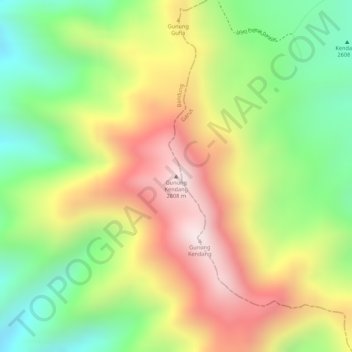
Name: Gunung Kendang topographic map, elevation, terrain.
Location: Gunung Kendang, Bandung, Java occidental, Indonésie (-7.24037 107.70675 -7.24027 107.70685)
Average elevation: 2,284 m
Minimum elevation: 1,984 m
Maximum elevation: 2,591 m
Other topographic maps
Click on a map to view its topography, its elevation and its terrain.
Gunung Patuha
Indonésie > Java occidental > Bandung
Gunung Patuha, Bandung, Java occidental, 40973, Indonésie
Average elevation: 2,103 m
Papandayan
Indonésie > Java occidental > Bandung
Papandayan, Bandung, Java occidental, Indonésie
Average elevation: 2,319 m