
Thank you for supporting this site ❤️
Make a donation
Make a donation
Pretzsch (Elbe) topographic map
Click on the map to display elevation.
Thank you for supporting this site ❤️
Make a donation
Make a donation
Pretzsch (Elbe)
Auf dem Schlossgelände entstand um 1900 eine Mädchenschule, in der höhere Töchter aus preußischen Familien auf ihre Zukunft vorbereitet wurden. Im Ersten Weltkrieg war das Schloss wieder als Lazarett genutzt worden. bevor es danach erneut als Waisenhaus diente. Auch eine Orgelbau-Werkstatt war hier untergebracht. Nach dem Zweiten Weltkrieg wurde das Schloss wieder ein staatliches Kinderheim. Inzwischen ist das Kinder- und Jugendheim „Adolf Reichwein“ Schloss Pretzsch in der Trägerschaft der Salus gGmbH.
Thank you for supporting this site ❤️
Make a donation
Make a donation
About this map
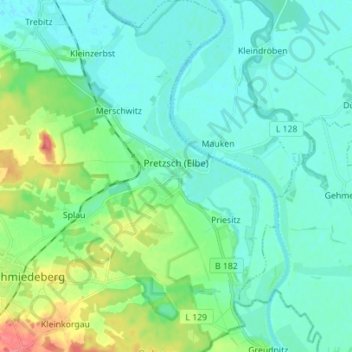
Name: Pretzsch (Elbe) topographic map, elevation, terrain.
Average elevation: 83 m
Minimum elevation: 69 m
Maximum elevation: 132 m
Thank you for supporting this site ❤️
Make a donation
Make a donation
Other topographic maps
Click on a map to view its topography, its elevation and its terrain.