
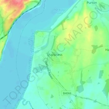
Sharpness topographic map
Interactive map
Click on the map to display elevation.
About this map
Name: Sharpness topographic map, elevation, terrain.
Average elevation: 17 m
Minimum elevation: -1 m
Maximum elevation: 75 m
Other topographic maps
Click on a map to view its topography, its elevation and its terrain.
Coombe Hill
United Kingdom > England > Gloucestershire > Stroud
Coombe Hill, Stroud, Gloucestershire, England, GL12 7NA, United Kingdom
Average elevation: 149 m
Hardwicke Green
United Kingdom > England > Gloucestershire > Stroud > Hardwicke
Hardwicke Green, Hardwicke, Stroud, Gloucestershire, England, GL2 4OD, United Kingdom
Average elevation: 21 m
Whitminster
United Kingdom > England > Gloucestershire > Stroud > Whitminster
Whitminster, Stroud, Gloucestershire, England, GL2 7PT, United Kingdom
Average elevation: 21 m