
Make a donation
Pusch Ridge topographic map
Click on the map to display elevation.
Make a donation
Pusch Ridge
Pusch Ridge is primarily made up of three distinct peaks, including (from southwest to northeast in orientation) Pusch Peak, Bighorn Mountain, and Table Mountain. Pusch Peak is the westernmost point in the Santa Catalina Mountains, and rises in elevation over 2,000 feet (610 m) to a peak elevation of 5,366 feet (1,636 m). Bighorn Mountain rises to an elevation about 5,662 feet (1,726 m) at the summit. Table Mountain rises in elevation to 6,265 feet (1,910 m). A minor peak, known as The Cleaver, is located between Pusch Peak and Bighorn Mountain, rising to a summit of about 4,912 feet (1,497 m).
Make a donation
About this map
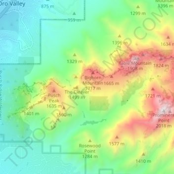
Name: Pusch Ridge topographic map, elevation, terrain.
Location: Pusch Ridge, Pima County, Arizona, 85704, United States (32.36209 -110.95758 32.38392 -110.89129)
Average elevation: 1,184 m
Minimum elevation: 778 m
Maximum elevation: 2,005 m
Make a donation
Other topographic maps
Click on a map to view its topography, its elevation and its terrain.
Sonoran Desert
United States > Arizona > Pima County
To the north in California and northwest Arizona, the Sonoran Desert transitions to the colder-winter, higher-elevation Mojave, Great Basin, and Colorado Plateau deserts.
Average elevation: 517 m
Make a donation
Drexel Heights
United States > Arizona > Pima County > Tucson
The area has numerous Saguaro cacti, and is positioned only a couple of miles south of the Saguaro National Park. The northern boundary of Drexel Heights is the Tucson Mountain Park. It is cut off from the rest of Tucson due to the topography of the Tucson Mountains, which are only crossed via a small number…
Average elevation: 786 m
Make a donation
Tucson
United States > Arizona > Pima County > Tucson
The city's elevation is 2,643 ft (806 m) above sea level (as measured at the Tucson International Airport). Tucson is on an alluvial plain in the Sonoran Desert, surrounded by five minor ranges of mountains: the Santa Catalina Mountains and the Tortolita Mountains to the north, the Santa Rita Mountains to the…
Average elevation: 836 m
Make a donation
Make a donation
Make a donation
Saguaro National Park - Tucson Mountain District
United States > Arizona > Pima County > Marana
Both districts conserve tracts of the Sonoran Desert, including ranges of significant hills, the Tucson Mountains in the west and the Rincon Mountains in the east. Elevations in the Tucson Mountain District range from 2,180 to 4,687 feet (664 to 1,429 m), the summit of Wasson Peak. Elevations within the Rincon…
Average elevation: 794 m
Make a donation
Make a donation