
Dilbeek topographic map
Interactive map
Click on the map to display elevation.
About this map
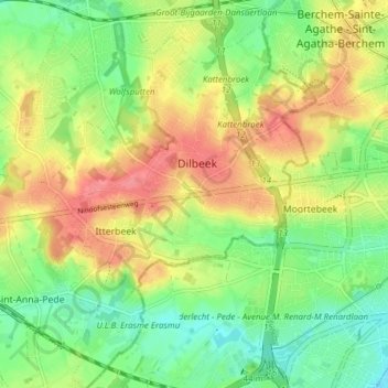
Name: Dilbeek topographic map, elevation, terrain.
Location: Dilbeek, Hal-Vilvorde, Brabant flamand, Flandre, 1700, Belgique (50.81989 4.22756 50.86846 4.28984)
Average elevation: 52 m
Minimum elevation: 20 m
Maximum elevation: 88 m
Other topographic maps
Click on a map to view its topography, its elevation and its terrain.
Chapelle-Saint-Ulric
Belgique > Brabant flamand > Hal-Vilvorde > Dilbeek
Chapelle-Saint-Ulric, Dilbeek, Hal-Vilvorde, Brabant flamand, Belgique
Average elevation: 49 m
Grand-Bigard
Belgique > Brabant flamand > Hal-Vilvorde > Dilbeek
Grand-Bigard, Dilbeek, Hal-Vilvorde, Brabant flamand, 1702, Belgique
Average elevation: 51 m
Itterbeek
Belgique > Brabant flamand > Hal-Vilvorde > Dilbeek
Itterbeek, Dilbeek, Hal-Vilvorde, Brabant flamand, Flandre, 1701, Belgique
Average elevation: 51 m
Schepdael
Belgique > Brabant flamand > Hal-Vilvorde > Dilbeek
Schepdael, Dilbeek, Hal-Vilvorde, Brabant flamand, Flandre, 1703, Belgique
Average elevation: 55 m