
Olen topographic map
Interactive map
Click on the map to display elevation.
About this map
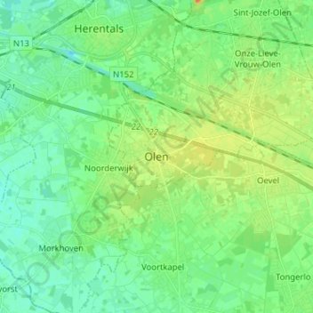
Name: Olen topographic map, elevation, terrain.
Location: Olen, Turnhout, Antwerpen, Vlaanderen, 2250, België (51.10386 4.81973 51.18386 4.89973)
Average elevation: 17 m
Minimum elevation: 5 m
Maximum elevation: 39 m
Other topographic maps
Click on a map to view its topography, its elevation and its terrain.
Sint-Jozef-Olen
België > Antwerpen > Turnhout > Olen
Sint-Jozef-Olen, Olen, Turnhout, Antwerpen, Vlaanderen, 2250, België
Average elevation: 16 m