
Thank you for supporting this site ❤️
Make a donation
Make a donation
Kampung Pulau Sekati topographic map
Click on the map to display elevation.
Thank you for supporting this site ❤️
Make a donation
Make a donation
About this map
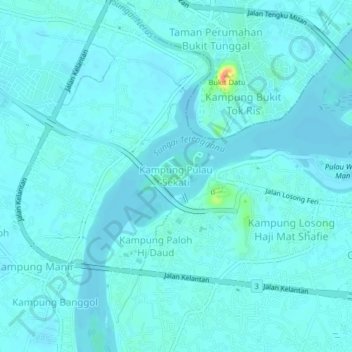
Name: Kampung Pulau Sekati topographic map, elevation, terrain.
Average elevation: 6 m
Minimum elevation: -1 m
Maximum elevation: 55 m
Thank you for supporting this site ❤️
Make a donation
Make a donation
Other topographic maps
Click on a map to view its topography, its elevation and its terrain.
Duyung Small Island
Malaysia > Terengganu > Kuala Terengganu > Kuala Terengganu
Average elevation: 4 m
Pak Mat Lebai Island
Malaysia > Terengganu > Kuala Terengganu > Kuala Terengganu
Average elevation: 6 m
Thank you for supporting this site ❤️
Make a donation
Make a donation
Batu Burok Public Park
Malaysia > Terengganu > Kuala Terengganu > Kuala Terengganu
Average elevation: 5 m
Thank you for supporting this site ❤️
Make a donation
Make a donation
Taman Tamadun Islam (Mini Islam)
Malaysia > Terengganu > Kuala Terengganu > Kuala Terengganu
Average elevation: 5 m