
1st District of Patras - Arctic Sector topographic map
Interactive map
Click on the map to display elevation.
About this map
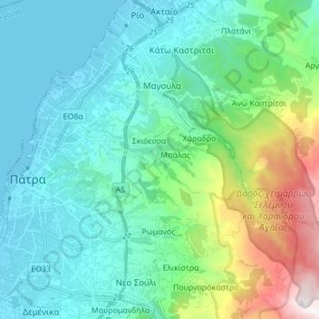
Name: 1st District of Patras - Arctic Sector topographic map, elevation, terrain.
Average elevation: 375 m
Minimum elevation: -3 m
Maximum elevation: 1,840 m
Other topographic maps
Click on a map to view its topography, its elevation and its terrain.
Kato Lousi
Greece > Peloponnese, Western Greece and the Ionian > Achaea Regional Unit > Municipality of Kalavryta
Kato Lousi, Municipality of Kalavryta, Achaea Regional Unit, Western Greece, Peloponnese, Western Greece and the Ionian, 250 01, Greece
Average elevation: 1,172 m
Municipality of Kalavryta
Greece > Peloponnese, Western Greece and the Ionian > Achaea Regional Unit
Municipality of Kalavryta, Achaea Regional Unit, Western Greece, Peloponnese, Western Greece and the Ionian, Greece
Average elevation: 975 m
Municipal Unit of Movri
Greece > Peloponnese, Western Greece and the Ionian > Achaea Regional Unit
Municipal Unit of Movri, Municipality of West Achaea, Achaea Regional Unit, Western Greece, Peloponnese, Western Greece and the Ionian, 250 05, Greece
Average elevation: 55 m
Patras
Greece > Peloponnese, Western Greece and the Ionian > Achaea Regional Unit > Patras
Patras, Municipal Unit of Patras, Municipality of Patras, Achaea Regional Unit, Western Greece, Peloponnese, Western Greece and the Ionian, 26221, Greece
Average elevation: 283 m