
Thank you for supporting this site ❤️
Make a donation
Make a donation
Bourg d'en Haut topographic map
Click on the map to display elevation.
Thank you for supporting this site ❤️
Make a donation
Make a donation
About this map
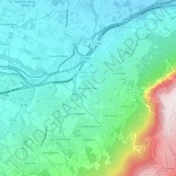
Name: Bourg d'en Haut topographic map, elevation, terrain.
Average elevation: 624 m
Minimum elevation: 424 m
Maximum elevation: 1,297 m
Thank you for supporting this site ❤️
Make a donation
Make a donation
Other topographic maps
Click on a map to view its topography, its elevation and its terrain.
Carrière
France > Auvergne-Rhône-Alpes > Haute-Savoie > Collonges-sous-Salève > La Combe
Average elevation: 759 m