
Make a donation
Ridgefield topographic map
Click on the map to display elevation.
Make a donation
Ridgefield
Ridgefield consists of hilly, rocky terrain, ranging from 1,060 feet (320 m) above sea level (at Pine Mountain) to 342 feet (104 m) at Branchville. Its average village elevation is 725 feet (221 m) above sea level. The landscape is strewn with countless rocks deposited by glaciers, and among the town's bodies of water is Round Pond, formed in a kettle left by the last glacier 20,000 years ago. Another interesting body of water in the town is Mamanasco Lake, an 86-acre (35 ha) lake near Ridgefield High School. A particularly interesting feature is Cameron's Line, named for Eugene N. Cameron, who discovered that rocks west of the line differed greatly from those east of it. This fault line was formed some 250 million years ago by the collision of "Proto North America" and "Proto Africa", and there are still occasional light earthquakes felt along its length. The line bisects the southern half of the town, running generally north of West Lane, across the north end of the village, past the south end of Great Swamp and generally easterly into Redding in the Topstone area. North of Cameron's Line, the town is rich in limestone. The mineral was extensively mined, and remnants of several limekilns exist today. Also mined here in the 19th century was mica, pegmatite, and quartz. Gold, as well as gemstones such as garnet and beryl, have been found here, and dozens of minerals have been unearthed at the old Branchville Mica Quarry. Uraninite, a source of uranium, is found here, too.
Make a donation
About this map
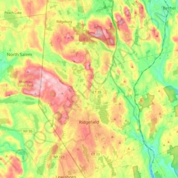
Name: Ridgefield topographic map, elevation, terrain.
Average elevation: 183 m
Minimum elevation: 79 m
Maximum elevation: 301 m
Make a donation
Other topographic maps
Click on a map to view its topography, its elevation and its terrain.
Germantown
United States > Connecticut > Western Connecticut Planning Region > Danbury
Average elevation: 121 m
Thomas Mountain
United States > Connecticut > Western Connecticut Planning Region > Danbury
Average elevation: 197 m
Ponus
United States > Connecticut > Western Connecticut Planning Region > New Canaan
Average elevation: 77 m
Great Plain
United States > Connecticut > Western Connecticut Planning Region > Danbury
Average elevation: 132 m
Make a donation
Byram
United States > Connecticut > Western Connecticut Planning Region > Greenwich
Average elevation: 19 m
North Mianus
United States > Connecticut > Western Connecticut Planning Region > Greenwich
Average elevation: 32 m
Saugatuck
United States > Connecticut > Western Connecticut Planning Region > Westport
Average elevation: 15 m
Five Points
United States > Connecticut > Western Connecticut Planning Region > Redding Ridge
Average elevation: 185 m
Make a donation
Daniels Mill
United States > Connecticut > Western Connecticut Planning Region > New Canaan
Average elevation: 100 m
Northfield
United States > Connecticut > Western Connecticut Planning Region > Stamford
Average elevation: 25 m
Chimney Point
United States > Connecticut > Western Connecticut Planning Region > New Milford
Average elevation: 142 m
Five Points
United States > Connecticut > Western Connecticut Planning Region > Redding Ridge
Average elevation: 185 m
Make a donation
Palestine
United States > Connecticut > Western Connecticut Planning Region > Newtown
Average elevation: 184 m
Mill River Park
United States > Connecticut > Western Connecticut Planning Region > Stamford
Average elevation: 18 m
Wildmans Landing
United States > Connecticut > Western Connecticut Planning Region > Danbury
Average elevation: 156 m
West Norwalk
United States > Connecticut > Western Connecticut Planning Region > Norwalk
Average elevation: 50 m
Make a donation
Godfrey Corner
United States > Connecticut > Western Connecticut Planning Region > Weston
Average elevation: 110 m
Bold Rock
United States > Connecticut > Western Connecticut Planning Region > Darien
Average elevation: 58 m
King Street
United States > Connecticut > Western Connecticut Planning Region > Danbury
Average elevation: 237 m
Godfrey Corner
United States > Connecticut > Western Connecticut Planning Region > Weston
Average elevation: 110 m
Make a donation
South End
United States > Connecticut > Western Connecticut Planning Region > Stamford
Average elevation: 11 m
Deer Hill
United States > Connecticut > Western Connecticut Planning Region > Danbury
Average elevation: 135 m
Long Ridge
United States > Connecticut > Western Connecticut Planning Region > Stamford
Average elevation: 126 m
Wataba Lake
United States > Connecticut > Western Connecticut Planning Region > Ridgefield
Average elevation: 205 m
Make a donation
Old Greenwich
United States > Connecticut > Western Connecticut Planning Region > Greenwich
Average elevation: 12 m
Winnipauk
United States > Connecticut > Western Connecticut Planning Region > Norwalk
Average elevation: 51 m
Town Open Space (Ashford Lane)
United States > Connecticut > Western Connecticut Planning Region > Newtown
Average elevation: 200 m
Tokeneke
United States > Connecticut > Western Connecticut Planning Region > Darien
Average elevation: 14 m
Make a donation
Roxbury
United States > Connecticut > Western Connecticut Planning Region > Stamford
Average elevation: 48 m
Candlewood Lake Club
United States > Connecticut > Western Connecticut Planning Region > New Milford
Average elevation: 143 m
Cannondale
United States > Connecticut > Western Connecticut Planning Region > Wilton
Average elevation: 110 m
Taylor Corners
United States > Connecticut > Western Connecticut Planning Region > New Fairfield
Average elevation: 226 m
Make a donation
Mianus
United States > Connecticut > Western Connecticut Planning Region > Greenwich
Average elevation: 23 m
Glenville
United States > Connecticut > Western Connecticut Planning Region > Greenwich
Average elevation: 54 m
North Stamford
United States > Connecticut > Western Connecticut Planning Region > Stamford
Average elevation: 89 m
Mianus
United States > Connecticut > Western Connecticut Planning Region > Greenwich
Average elevation: 23 m
Make a donation
Belltown
United States > Connecticut > Western Connecticut Planning Region > Stamford
Average elevation: 32 m
Palmers Hill
United States > Connecticut > Western Connecticut Planning Region > Stamford
Average elevation: 31 m
Taylor Corners
United States > Connecticut > Western Connecticut Planning Region > New Fairfield
Average elevation: 226 m
Beckettville
United States > Connecticut > Western Connecticut Planning Region > Danbury
Average elevation: 155 m
Make a donation
Contentment Island
United States > Connecticut > Western Connecticut Planning Region > Darien
Average elevation: 63 m
Pinneys Corners
United States > Connecticut > Western Connecticut Planning Region > New Canaan
Average elevation: 143 m
Riverside
United States > Connecticut > Western Connecticut Planning Region > Greenwich > Old Greenwich
Average elevation: 13 m
Sandy Hook
United States > Connecticut > Western Connecticut Planning Region > Newtown
Average elevation: 113 m
Make a donation
Beaver Brook
United States > Connecticut > Western Connecticut Planning Region > Danbury
Average elevation: 119 m
Riverbank
United States > Connecticut > Western Connecticut Planning Region > Stamford
Average elevation: 72 m
Honey Hill
United States > Connecticut > Western Connecticut Planning Region > Wilton
Average elevation: 126 m
Turn of River
United States > Connecticut > Western Connecticut Planning Region > Stamford
Average elevation: 58 m
Make a donation
Riverside
United States > Connecticut > Western Connecticut Planning Region > Greenwich > Old Greenwich
Average elevation: 13 m
Candlewood Springs
United States > Connecticut > Western Connecticut Planning Region > New Milford
Average elevation: 146 m
Candlewood Orchards
United States > Connecticut > Western Connecticut Planning Region > Brookfield
Average elevation: 141 m