
Thank you for supporting this site ❤️
Make a donation
Make a donation
Mwangaza topographic map
Click on the map to display elevation.
Thank you for supporting this site ❤️
Make a donation
Make a donation
About this map
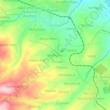
Name: Mwangaza topographic map, elevation, terrain.
Location: Mwangaza, Turi ward, Molo, Nakuru, Kenya (-0.29002 35.72414 -0.25002 35.76414)
Average elevation: 2,491 m
Minimum elevation: 2,379 m
Maximum elevation: 2,641 m
Thank you for supporting this site ❤️
Make a donation
Make a donation