
Thank you for supporting this site ❤️
Make a donation
Make a donation
Chukai topographic map
Click on the map to display elevation.
Thank you for supporting this site ❤️
Make a donation
Make a donation
About this map
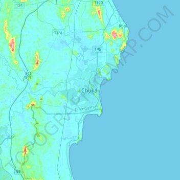
Name: Chukai topographic map, elevation, terrain.
Location: Chukai, Kemaman District, Terengganu, 24000, Malaysia (4.05931 103.26252 4.37931 103.58252)
Average elevation: 12 m
Minimum elevation: -1 m
Maximum elevation: 306 m
Thank you for supporting this site ❤️
Make a donation
Make a donation
Other topographic maps
Click on a map to view its topography, its elevation and its terrain.
Thank you for supporting this site ❤️
Make a donation
Make a donation
Sungai Kandang Rusa
Malaysia > Terengganu > Kemaman District > Kampung Semayor
Average elevation: 32 m