
Thank you for supporting this site ❤️
Make a donation
Make a donation
De Eng topographic map
Click on the map to display elevation.
Thank you for supporting this site ❤️
Make a donation
Make a donation
About this map
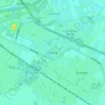
Name: De Eng topographic map, elevation, terrain.
Location: De Eng, Duiven, Gelderland, Nederland, 6921 PR, Nederland (51.93730 5.98628 51.97730 6.02628)
Average elevation: 11 m
Minimum elevation: 6 m
Maximum elevation: 29 m
Thank you for supporting this site ❤️
Make a donation
Make a donation