
Thank you for supporting this site ❤️
Make a donation
Make a donation
Cornelli topographic map
Click on the map to display elevation.
Thank you for supporting this site ❤️
Make a donation
Make a donation
About this map
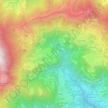
Name: Cornelli topographic map, elevation, terrain.
Location: Cornelli, Brumano, Bergamo, Lombardia, 24037, Italia (45.83472 9.48478 45.87472 9.52478)
Average elevation: 1,054 m
Minimum elevation: 472 m
Maximum elevation: 1,739 m
Thank you for supporting this site ❤️
Make a donation
Make a donation
Other topographic maps
Click on a map to view its topography, its elevation and its terrain.