
Thank you for supporting this site ❤️
Make a donation
Make a donation
Sheopur topographic map
Click on the map to display elevation.
Thank you for supporting this site ❤️
Make a donation
Make a donation
Sheopur
Sheopur is located at 25°40′N 76°42′E / 25.67°N 76.7°E / 25.67; 76.7. It has an average elevation of 229 metres (751 feet).
Thank you for supporting this site ❤️
Make a donation
Make a donation
About this map
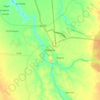
Name: Sheopur topographic map, elevation, terrain.
Average elevation: 233 m
Minimum elevation: 210 m
Maximum elevation: 256 m
Thank you for supporting this site ❤️
Make a donation
Make a donation
Other topographic maps
Click on a map to view its topography, its elevation and its terrain.