
Make a donation
Pindus topographic map
Click on the map to display elevation.
Make a donation
Pindus
The Pindus (also Pindos or Pindhos; Greek: Πίνδος, romanized: Píndos; Albanian: Pindet; Aromanian: Pindu) is a mountain range located in Northern Greece and Southern Albania. It is roughly 160 km (99 mi) long, with a maximum elevation of 2,637 metres (8,652 ft) (Mount Smolikas). Because it runs north to south along much of mainland Greece, the Pindus range is known colloquially as the spine of Greece. The mountain range stretches from near the Greek-Albanian border in southern Albania, entering the Epirus and Macedonia regions in northern Greece down to the north of the Peloponnese. Geologically, it is an extension of the Dinaric Alps, which dominate the western region of the Balkan Peninsula.
Make a donation
About this map
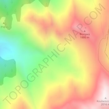
Name: Pindus topographic map, elevation, terrain.
Average elevation: 1,510 m
Minimum elevation: 942 m
Maximum elevation: 2,013 m
Make a donation
Other topographic maps
Click on a map to view its topography, its elevation and its terrain.
Municipal Unit of Tamasi
Greece > Thessaly and Central Greece > Karditsa Regional Unit
Average elevation: 293 m
Plastiras (Tavropos) Lake
Greece > Thessaly and Central Greece > Karditsa Regional Unit > Plastiras Municipal Unit
Today the lake holds up to 400 million cubic meters of fresh water. It is used for irrigation and as a power source of a hydroelectric plant, but also as the main water source to the city of Karditsa. Due to its altitude (one of the highest in Europe) the Tavropos Reservoir is a popular tourist resort in…
Average elevation: 792 m