
Thank you for supporting this site ❤️
Make a donation
Make a donation
Picos de Europa topographic map
Click on the map to display elevation.
Thank you for supporting this site ❤️
Make a donation
Make a donation
Picos de Europa
The Picos de Europa ("Peaks of Europe", also the Picos) are a mountain range extending for about 20 km (12 mi), forming part of the Cantabrian Mountains in northern Spain. The range is situated in the Autonomous Communities of Asturias, Cantabria and Castile and León. The highest peak is Torre de Cerredo, at an elevation of 2650 m (8,690 ft).
Thank you for supporting this site ❤️
Make a donation
Make a donation
About this map
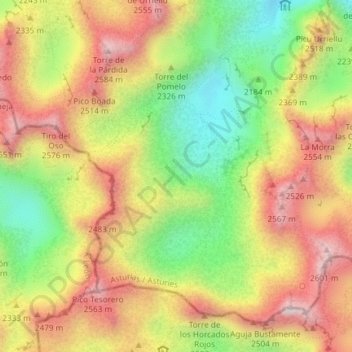
Name: Picos de Europa topographic map, elevation, terrain.
Location: Picos de Europa, Cabrales, Asturias, Spain (43.18955 -4.83280 43.18965 -4.83270)
Average elevation: 2,290 m
Minimum elevation: 1,953 m
Maximum elevation: 2,606 m
Thank you for supporting this site ❤️
Make a donation
Make a donation
Other topographic maps
Click on a map to view its topography, its elevation and its terrain.
Thank you for supporting this site ❤️
Make a donation
Make a donation