
Thank you for supporting this site ❤️
Make a donation
Make a donation
Murtosa topographic map
Click on the map to display elevation.
Thank you for supporting this site ❤️
Make a donation
Make a donation
About this map
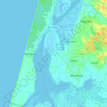
Name: Murtosa topographic map, elevation, terrain.
Location: Murtosa, Aveiro, Portugal (40.70209 -8.73528 40.81963 -8.59370)
Average elevation: 3 m
Minimum elevation: -3 m
Maximum elevation: 27 m
Thank you for supporting this site ❤️
Make a donation
Make a donation
Other topographic maps
Click on a map to view its topography, its elevation and its terrain.