
Thank you for supporting this site ❤️
Make a donation
Make a donation
Jind topographic map
Click on the map to display elevation.
Thank you for supporting this site ❤️
Make a donation
Make a donation
Jind
Jind is located at 29°19′N 76°19′E / 29.32°N 76.32°E / 29.32; 76.32. It has an average elevation of 227 metres (744 feet).
Thank you for supporting this site ❤️
Make a donation
Make a donation
About this map
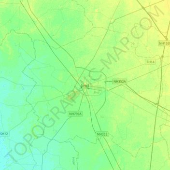
Name: Jind topographic map, elevation, terrain.
Location: Jind, Haryana, 126100, India (29.15404 76.15795 29.47404 76.47795)
Average elevation: 226 m
Minimum elevation: 219 m
Maximum elevation: 235 m
Thank you for supporting this site ❤️
Make a donation
Make a donation