Geolocate

Foel Penolau topographic map

Click on the map to display elevation.

About this map

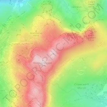
Name: Foel Penolau topographic map, elevation, terrain.

Location: Foel Penolau, Gwynedd, Wales, LL41 4TS, United Kingdom (52.89408 -3.99088 52.89418 -3.99078)

Average elevation: 423 m

Minimum elevation: 221 m

Maximum elevation: 611 m

Other topographic maps

Click on a map to view its topography, its elevation and its terrain.

Llanedi

United Kingdom > Wales > Carmarthenshire > Llanedi

Average elevation: 104 m

Brecon Beacons

United Kingdom > Wales > Powys > Libanus

Average elevation: 436 m

Llanedi

United Kingdom > Wales > Carmarthenshire > Llanedi

Average elevation: 104 m

South Wales

United Kingdom > Wales

Average elevation: 163 m

Newport

United Kingdom > Wales

Average elevation: 58 m

Pembrokeshire

United Kingdom > Wales

There is little evidence of Roman occupation in what is now Pembrokeshire. Ptolemy's Geography, written c. 150, mentioned some coastal places, two of which have been identified as the River Teifi and what is now St Davids Head, but most Roman writers did not mention the area; there may have been a Roman…

Average elevation: 43 m

Barry

United Kingdom > Wales > Vale of Glamorgan

Average elevation: 29 m

Barry

United Kingdom > Wales > Vale of Glamorgan

Average elevation: 29 m

Powys

United Kingdom > Wales

Average elevation: 216 m

North Wales

United Kingdom > Wales

Average elevation: 125 m

Isle of Anglesey

United Kingdom > Wales

Average elevation: 49 m

Brecon Beacons National Park

United Kingdom > Wales > Powys

Brecon Beacons National Park, officially named Bannau Brycheiniog National Park (Welsh pronunciation), is a national park in Wales. It is named after the Brecon Beacons (Welsh: Bannau Brycheiniog), the mountain range at its centre. The national park includes the highest mountain in South Wales, Pen y Fan,…

Average elevation: 270 m

Newport

United Kingdom > Wales

Average elevation: 58 m

Llyn Gwynant

United Kingdom > Wales > Gwynedd > Beddgelert > Nantgwynant

Average elevation: 246 m

Morriston

United Kingdom > Wales > Swansea > Swansea

Average elevation: 66 m

Pembrokeshire

United Kingdom > Wales

Average elevation: 43 m

Wrexham

United Kingdom > Wales

Average elevation: 150 m

Ponthir

United Kingdom > Wales > Torfaen

Average elevation: 48 m

Blorenge

United Kingdom > Wales > Monmouthshire > Govilon

Average elevation: 394 m

Llanwern

United Kingdom > Wales > Newport > Llanwern

Average elevation: 23 m

Carmarthenshire

United Kingdom > Wales

Average elevation: 142 m

Betws Gwerfil Goch

United Kingdom > Wales > Denbighshire

Average elevation: 297 m

North Wales

United Kingdom > Wales

Average elevation: 125 m

Bullwell Bay

United Kingdom > Wales

Average elevation: 14 m

Pembroke Dock

United Kingdom > Wales > Pembrokeshire

Average elevation: 19 m

Anglesey

United Kingdom > Wales > Isle of Anglesey

Average elevation: 43 m

Brecon Beacons

United Kingdom > Wales > Powys > Libanus

Average elevation: 436 m

Menai Bridge

United Kingdom > Wales > Isle of Anglesey

Average elevation: 48 m

Pontardawe

United Kingdom > Wales > Neath Port Talbot

Average elevation: 180 m

Abernant

United Kingdom > Wales > Carmarthenshire

Average elevation: 158 m

Carmarthenshire

United Kingdom > Wales

Average elevation: 142 m

Neath

United Kingdom > Wales > Neath Port Talbot

Average elevation: 71 m

Clawddnewydd

United Kingdom > Wales > Denbighshire

Average elevation: 246 m

Llyn y Fan Fach

United Kingdom > Wales > Carmarthenshire

Llyn y Fan Fach (Welsh meaning "little lake of the peak") is a lake of approximately 10 hectares (25 acres) on the northern margin of the Black Mountain in Carmarthenshire, South Wales and lying within the Brecon Beacons National Park. The lake lies at an altitude of approximately 1,660 feet (510 m),…

Average elevation: 549 m

St. Julians

United Kingdom > Wales > Newport

Average elevation: 23 m

Sams Wood

United Kingdom > Wales > Pembrokeshire > Llangwm > Martletwy

Average elevation: 26 m

Coed Maes-gwyn

United Kingdom > Wales > Gwynedd > Llanuwchllyn

Average elevation: 224 m

Llywel

United Kingdom > Wales > Powys > Trecastle

Average elevation: 363 m

Mid Glamorgan

United Kingdom > Wales > Rhondda Cynon Taf

Average elevation: 235 m

Crynant

United Kingdom > Wales > Neath Port Talbot

Average elevation: 232 m

Old Colwyn

United Kingdom > Wales > Conwy

Average elevation: 75 m

Carmarthenshire

United Kingdom > Wales

Average elevation: 142 m

Llansamlet

United Kingdom > Wales > Swansea > Tregof

Average elevation: 32 m

Pontypridd

United Kingdom > Wales > Rhondda Cynon Taf

Average elevation: 183 m

River Taff

United Kingdom > Wales > Cardiff > Pontypridd

Average elevation: 12 m

Llanaelhaearn

United Kingdom > Wales > Gwynedd

Average elevation: 147 m

Valley

United Kingdom > Wales > Isle of Anglesey

Average elevation: 6 m

River Dee

United Kingdom > Wales > Denbighshire > Corwen > Bonwm

Average elevation: 244 m

Craig-y-Nôs Castle

United Kingdom > Wales > Powys > Pen y Cae

Average elevation: 307 m

Newport

United Kingdom > Wales

Average elevation: 58 m

Conwy

United Kingdom > Wales

Average elevation: 254 m

River Monnow

United Kingdom > Wales > Monmouthshire

Average elevation: 172 m

Barry

United Kingdom > Wales > Vale of Glamorgan

Average elevation: 29 m

Llyn Idwal

United Kingdom > Wales > Gwynedd

Average elevation: 571 m

Llanbedr

United Kingdom > Wales > Gwynedd

Average elevation: 252 m

Roath

United Kingdom > Wales > Cardiff > Cardiff

Average elevation: 20 m

Beguildy

United Kingdom > Wales > Powys

Average elevation: 363 m

Hayscastle

United Kingdom > Wales > Pembrokeshire

Average elevation: 103 m

Clwydian Range and Dee Valley National Landscape

United Kingdom > Wales > Denbighshire

Separated by the Vale of Alyn, a second sister range, sometimes regarded (at least partly) as part of the Clwydian Range and included in the AONB since 2011, the Llantysilio and Maesyrchen Mountains, or South Clwyd Mountains extend further south to Acrefair and Gwyddelwern. Alongside the (core–northern)…

Average elevation: 166 m

Newport

United Kingdom > Wales

Average elevation: 58 m

Penylan

United Kingdom > Wales > Cardiff > Cardiff

Average elevation: 24 m

Gabalfa

United Kingdom > Wales > Cardiff > Cardiff

Average elevation: 23 m

Blaina

United Kingdom > Wales > Blaenau Gwent > Cwmcelyn

Average elevation: 397 m

Stack Rock Fort

United Kingdom > Wales > Pembrokeshire > Angle

Average elevation: 6 m

Powis Castle

United Kingdom > Wales > Powys > Welshpool > Belan

Average elevation: 124 m

Llyn Nantlle Uchaf

United Kingdom > Wales > Gwynedd > Nantlle

Average elevation: 204 m

Penmaenmawr

United Kingdom > Wales > Conwy > Penmaenmawr

Average elevation: 195 m

Flintshire

United Kingdom > Wales

Average elevation: 104 m

Cardiff Pond

United Kingdom > Wales > Blaenau Gwent > Ebbw Vale

Average elevation: 349 m

Sketty

United Kingdom > Wales > Swansea > Swansea

Average elevation: 64 m

Eryri National Park

United Kingdom > Wales > Gwynedd

Average elevation: 217 m

Crucorney

United Kingdom > Wales > Monmouthshire

Average elevation: 297 m

Llanfaelog

United Kingdom > Wales > Isle of Anglesey

Average elevation: 16 m

Point of Ayr

United Kingdom > Wales > Flintshire > Talacre

Average elevation: 2 m

Carmarthenshire

United Kingdom > Wales

Average elevation: 142 m

Llangelynin

United Kingdom > Wales > Gwynedd

Average elevation: 56 m

Pentir

United Kingdom > Wales > Gwynedd

Average elevation: 82 m

Ilston

United Kingdom > Wales > Swansea

Average elevation: 61 m

Ford

United Kingdom > Wales > Gwynedd > Llandderfel

Average elevation: 219 m

Gwynedd

United Kingdom > Wales

Average elevation: 199 m

Bute Park

United Kingdom > Wales > Cardiff > Cardiff

Average elevation: 14 m

Eglwysbach

United Kingdom > Wales > Conwy > Eglwys-bach

Average elevation: 172 m