
Thank you for supporting this site ❤️
Make a donation
Make a donation
Garden Plain topographic map
Click on the map to display elevation.
Thank you for supporting this site ❤️
Make a donation
Make a donation
About this map
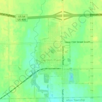
Name: Garden Plain topographic map, elevation, terrain.
Location: Garden Plain, Sedgwick County, Kansas, United States (37.65224 -97.68917 37.66963 -97.67095)
Average elevation: 444 m
Minimum elevation: 433 m
Maximum elevation: 452 m
Thank you for supporting this site ❤️
Make a donation
Make a donation
Other topographic maps
Click on a map to view its topography, its elevation and its terrain.
Valley Center
United States > Kansas > Sedgwick County > Valley Center > Valley Center
Average elevation: 415 m