
Western Development Region topographic map
Interactive map
Click on the map to display elevation.
About this map
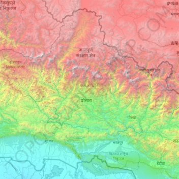
Name: Western Development Region topographic map, elevation, terrain.
Location: Western Development Region, Nepal (27.33016 82.69618 29.33061 85.19783)
Average elevation: 2,421 m
Minimum elevation: 81 m
Maximum elevation: 7,949 m
Other topographic maps
Click on a map to view its topography, its elevation and its terrain.
Pokhara Lekhnath Metropolitan Ward No. 16
Nepal > Western Development Region > Maidan
Pokhara Lekhnath Metropolitan Ward No. 16, Maidan, Pokhara Lekhnath Metropolitan, Kaski, Gandaki, Western Development Region, 60600, Nepal
Average elevation: 1,228 m
Kali Gandaki
Nepal > Western Development Region
Kali Gandaki, Baglung, Dhaulagiri, Western Development Region, 063, Nepal
Average elevation: 3,111 m
Darling
Nepal > Western Development Region > Darling
Darling, Gulmi, Lumbini, Western Development Region, Nepal
Average elevation: 1,681 m
Mardi Himal
Nepal > Western Development Region > Machhapuchhre
Mardi Himal, Machhapuchhre, Kaski, Gandaki, Western Development Region, Nepal
Average elevation: 4,967 m
Annapurna I
Nepal > Western Development Region > Ghandruk
Annapurna I, Ghandruk, Kaski, Gandaki, Western Development Region, Nepal
Average elevation: 7,127 m
Muna
Nepal > Western Development Region > Muna
Muna, Myagdi, Dhaulagiri, Western Development Region, Nepal
Average elevation: 2,230 m
Gandaki
Nepal > Western Development Region
Gandaki, Western Development Region, Nepal
Average elevation: 2,842 m
Annapurna II
Nepal > Western Development Region > Parche
Annapurna II, Parche, Kaski, Gandaki, Western Development Region, Nepal
Average elevation: 7,052 m