
Thank you for supporting this site ❤️
Make a donation
Make a donation
Coswig (Anhalt) topographic map
Click on the map to display elevation.
Thank you for supporting this site ❤️
Make a donation
Make a donation
About this map
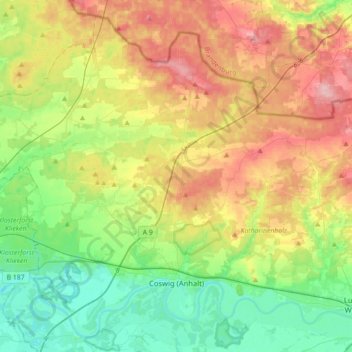
Name: Coswig (Anhalt) topographic map, elevation, terrain.
Location: Coswig (Anhalt), Wittenberg, Saxony-Anhalt, Germany (51.84681 12.25221 52.04480 12.60418)
Average elevation: 108 m
Minimum elevation: 52 m
Maximum elevation: 192 m
Thank you for supporting this site ❤️
Make a donation
Make a donation
Other topographic maps
Click on a map to view its topography, its elevation and its terrain.