
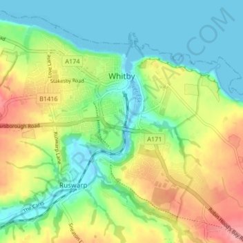
Whitby topographic map
Interactive map
Click on the map to display elevation.
About this map
Name: Whitby topographic map, elevation, terrain.
Average elevation: 37 m
Minimum elevation: -4 m
Maximum elevation: 99 m
Other topographic maps
Click on a map to view its topography, its elevation and its terrain.
Great Ayton
Vereinigtes Königreich > England > North Yorkshire
Great Ayton, North Yorkshire, England, Vereinigtes Königreich
Average elevation: 119 m
Hawes
Vereinigtes Königreich > England > North Yorkshire
Hawes, North Yorkshire, England, Vereinigtes Königreich
Average elevation: 430 m
Langbar
Vereinigtes Königreich > England > North Yorkshire
Langbar, Beamsley, North Yorkshire, England, LS29 0ER, Vereinigtes Königreich
Average elevation: 194 m
Normanby
Vereinigtes Königreich > England > North Yorkshire
Normanby, North Yorkshire, England, YO62 6RH, Vereinigtes Königreich
Average elevation: 31 m
Settle
Vereinigtes Königreich > England > North Yorkshire
Settle, North Yorkshire, England, Vereinigtes Königreich
Average elevation: 238 m
Hasty Bank
Vereinigtes Königreich > England > North Yorkshire > Ingleby Greenhow
Hasty Bank, Bilsdale Midcable, Ingleby Greenhow, North Yorkshire, England, Vereinigtes Königreich
Average elevation: 240 m
Carlton in Cleveland
Vereinigtes Königreich > England > North Yorkshire
Carlton in Cleveland, North Yorkshire, England, TS9 7DJ, Vereinigtes Königreich
Average elevation: 120 m
Muker
Vereinigtes Königreich > England > North Yorkshire > Richmondshire
Muker, Richmondshire, North Yorkshire, England, Vereinigtes Königreich
Average elevation: 479 m
Dalton-on-Tees
Vereinigtes Königreich > England > North Yorkshire > Richmondshire > Dalton-on-Tees
Dalton-on-Tees, Richmondshire, North Yorkshire, Yorkshire and the Humber, England, DL2 2PA, Vereinigtes Königreich
Average elevation: 46 m
Selby
Vereinigtes Königreich > England > North Yorkshire > Selby
Selby, North Yorkshire, Yorkshire and the Humber, England, Vereinigtes Königreich
Average elevation: 7 m