
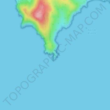
Cap Lardier topographic map
Interactive map
Click on the map to display elevation.
About this map
Name: Cap Lardier topographic map, elevation, terrain.
Average elevation: 10 m
Minimum elevation: 0 m
Maximum elevation: 139 m
Other topographic maps
Click on a map to view its topography, its elevation and its terrain.
Col de Collebasse
France > Provence-Alpes-Côte d'Azur > La Croix-Valmer > Gigaro
Col de Collebasse, Boulevard Georges Selliez, Gigaro, La Croix-Valmer, Draguignan, Var, Provence-Alpes-Côte d'Azur, France métropolitaine, 83420, France
Average elevation: 87 m
Plage de Gigaro
France > Provence-Alpes-Côte d'Azur > La Croix-Valmer
Plage de Gigaro, Boulevard de Gigaro, La Croix-Valmer, Draguignan, Var, Provence-Alpes-Côte d'Azur, France métropolitaine, 83420, France
Average elevation: 43 m