
Kedgwick topographic map
Interactive map
Click on the map to display elevation.
About this map
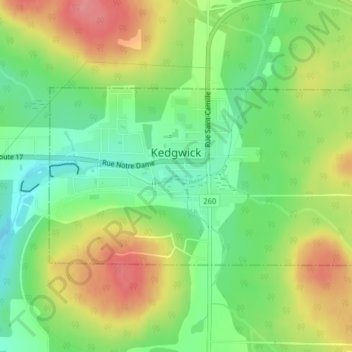
Name: Kedgwick topographic map, elevation, terrain.
Average elevation: 291 m
Minimum elevation: 252 m
Maximum elevation: 339 m
Other topographic maps
Click on a map to view its topography, its elevation and its terrain.
Réserve faunique de Rimouski
Canada > Nouveau-Brunswick > Comté de Restigouche
Réserve faunique de Rimouski, Comté de Restigouche, Bas-Saint-Laurent, Nouveau-Brunswick, Canada
Average elevation: 383 m
Saint-Quentin
Canada > Nouveau-Brunswick > Comté de Restigouche > Saint-Quentin
Saint-Quentin, Saint Quentin Parish, Comté de Restigouche, Nouveau-Brunswick, E8A 1H5, Canada
Average elevation: 284 m