
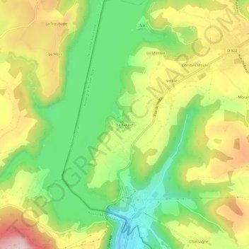
La Siauve topographic map
Interactive map
Click on the map to display elevation.
About this map
Name: La Siauve topographic map, elevation, terrain.
Average elevation: 588 m
Minimum elevation: 428 m
Maximum elevation: 783 m
Other topographic maps
Click on a map to view its topography, its elevation and its terrain.
Château de Val
France > Auvergne-Rhône-Alpes > Cantal > Lanobre > Val
Château de Val, Route du Château de Val, Val, Lanobre, Mauriac, Cantal, Auvergne-Rhône-Alpes, France métropolitaine, 15270, France
Average elevation: 583 m
Morange
France > Auvergne-Rhône-Alpes > Cantal > Lanobre
Morange, Lanobre, Mauriac, Cantal, Auvergne-Rhône-Alpes, France métropolitaine, 15270, France
Average elevation: 625 m