
Thank you for supporting this site ❤️
Make a donation
Make a donation
Heerte topographic map
Click on the map to display elevation.
Thank you for supporting this site ❤️
Make a donation
Make a donation
About this map
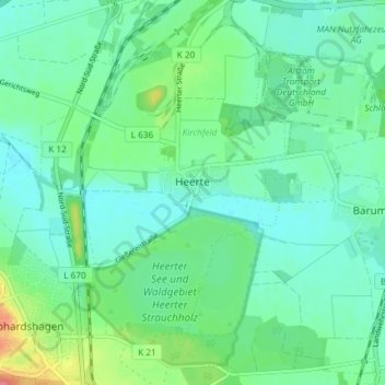
Name: Heerte topographic map, elevation, terrain.
Location: Heerte, Ortschaft West, Salzgitter, Niedersachsen, Deutschland (52.10074 10.35903 52.14599 10.40683)
Average elevation: 103 m
Minimum elevation: 86 m
Maximum elevation: 154 m
Thank you for supporting this site ❤️
Make a donation
Make a donation
Other topographic maps
Click on a map to view its topography, its elevation and its terrain.
Salzgitter
Deutschland > Niedersachsen > Salzgitter
Salzgitter liegt in einer breiten lössbedeckten Mulde zwischen dem Oderwald im Osten und den Lichtenbergen (Nordwestteil des Salzgitter-Höhenzugs) im westlichen Teil des Stadtgebiets sowie dem nördlichen Mittelteil des Salzgitter-Höhenzugs im südlichen Stadtgebiet. Die Stadt wird etwa in…
Average elevation: 111 m
Thank you for supporting this site ❤️
Make a donation
Make a donation