
Thank you for supporting this site ❤️
Make a donation
Make a donation
Dammberg topographic map
Click on the map to display elevation.
Thank you for supporting this site ❤️
Make a donation
Make a donation
About this map
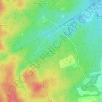
Name: Dammberg topographic map, elevation, terrain.
Average elevation: 76 m
Minimum elevation: 48 m
Maximum elevation: 113 m
Thank you for supporting this site ❤️
Make a donation
Make a donation
Other topographic maps
Click on a map to view its topography, its elevation and its terrain.
Bauerschaft Hachhausen
Deutschland > Nordrhein-Westfalen > Kreis Recklinghausen > Datteln
Average elevation: 67 m
Meckinghoven
Deutschland > Nordrhein-Westfalen > Kreis Recklinghausen > Datteln
Average elevation: 67 m
Thank you for supporting this site ❤️
Make a donation
Make a donation
Dortmund-Ems-Kanal
Deutschland > Nordrhein-Westfalen > Kreis Recklinghausen > Datteln
Average elevation: 55 m